

 Global
  United States
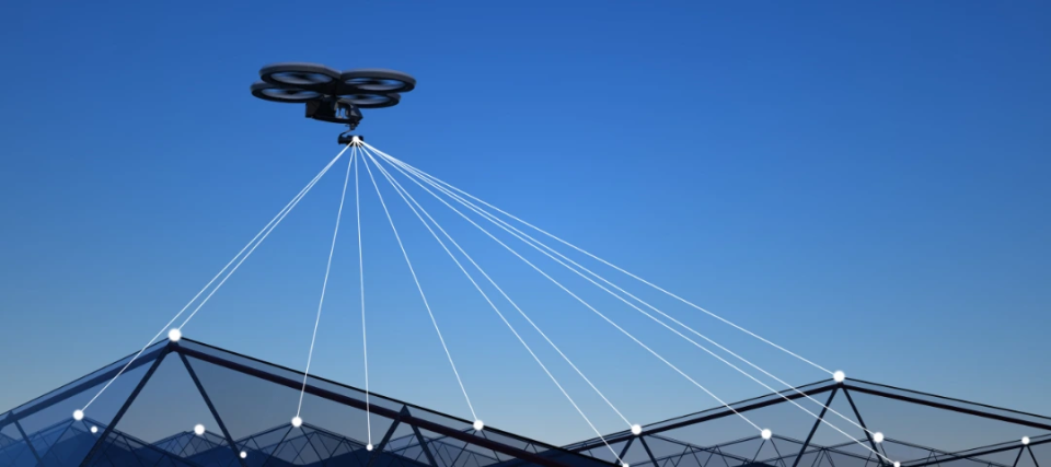
What is a Drone Security System?
In this contemporary world, interconnected smart cities rely on hyperconnectivity, accuracy, safety, speed, personalization, and intelligent predictions, as complexity in urban structures may result in shortcomings such as lack of resources to meet demands in real-time. With the growing population, the inability of humans to navigate this urban complexity, and increasing occurrences of hyperlocal issues like petty crimes like theft and vandalism, traffic accidents, terrorism, and natural disasters, traditional tools used for public safety are unable to deter such physical security incidents or meet the current operational demands for complete safety. The need of the hour is cost-effective and flexible aerial surveillance technology rendered with autonomous drones that are intelligently driven by artificial intelligence and computer vision for task execution and can overcome the cons caused by human delay.
A drone security system involves a set of strategies, techniques, and tools, like unmanned flying machines that are drones, and technologies that can patrol, detect with intelligent multispectral sensors, inspect and track in high resolution, and at times neutralize causes of potential security risks. These systems are usually deployed in military bases, seaports or docks, airports, refineries, industrial facilities, colleges and universities, railway stations, large public events, religious festivities, and certain infrastructure sites of critical importance that transcend human limits for protecting people, inventory, and assets. As virtual eyes in the sky, custom drone services enable these systems to provide situational awareness through real-time video feed, even in zero visibility or at night, to command centers and urban authorities. These maintain safer environments against business disruptions, lowering brand reputation, and customer satisfaction.
The market for drones powered by AI in security and surveillance is approximately valued at US $2,560.8 million as of 2025 and is expected to increase at a CAGR of 18.1% till 2032 to reach a value of about US $8,205.9 million. The major factors for this growth include the increasing number of applications for drones in the land industry, defense, and government sectors worldwide, such as autonomous transportation, event, disaster, and crowd management, and video surveillance operations. Let us explore in this blog how enterprises are using drones over traditional surveillance systems, such as armed guards, expensive helicopter and manned aircraft patrols, or Closed-Circuit Television (CCTV) networks, and shaping the future of aerial monitoring technologies.
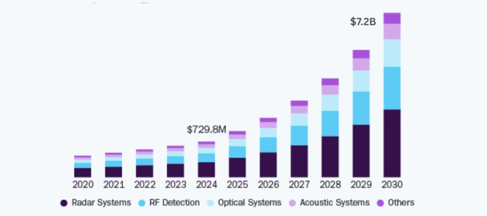
Source: Grand View Research
Growing market size of drone security system for home during 2020 to 2030 forecast period
Implications of AI in Drone Security Services
The global security and surveillance landscape is rapidly evolving with the growing synergy between Artificial Intelligence (AI), Machine Learning (ML), Deep Learning (DL), Computer Vision (CV) applications on real-time video feeds, and drone technology. Not only does this help in proactive management of threats, disasters, accidents, immediate intervention and responses, and in-depth situational analysis but also forms the backbone of contemporary apparatuses for overall security. We now delve into the transformative intersection, components, and implications of AI systems in drone-based security endeavors in this section.
Intelligent Swarm Coordination
AI can be used in rendering effective communication between multiple drones that may be deployed for scrutinizing security parameters across large construction areas. It helps in establishing notable swarm intelligence and accomplishing tactful collaboration between the drones deployed for task execution. It assists in avoiding collisions between them, sharing operational tasks, and optimizing overall coverage during the operations.
Real-time Edge Computing
In cases of critical missions, large amounts of data and video feeds are required to be processed in real-time by drones. This task may become quite complex, time-consuming, or inefficient if the drones need to rely on distantly placed servers via cloud connectivity. An alternative to this traditional security system is edge computing, which allows data to be analyzed locally for real-time processing. This especially assists with surveillance drones at night to track fast-moving targets and avoid sudden obstacles.
Smart Path Planning & Navigation
Using advanced AI-based algorithms, drones can autonomously navigate through heavily crowded environments and smart cities for executing tasks such as package deliveries. These systems map the surrounding areas and find the optimal route to the designated delivery destination. It is a notable point that these perform such actions without any human intervention during the operation even if there are occurrences of GPS-denied or low-visibility areas, rugged builds, EO-IR payloads, challenging terrains, unpredictable obstacles, and disrupting weather conditions like desert sandstorms, buildings, other drones, or power lines on the pathway. Post-deployment path planning that works Beyond the Visual Line of Sight (BVLOS) ensures that the mission gets accomplished in an efficient manner at all costs.
Autonomous Decision-Making
AI and CV-powered drones can perform smooth operations through autonomous decision-making as per the data collected on the path to executing tasks. The advanced control systems embedded ensure that these systems can adjust their altitude, delay or hasten delivery, change directions, reroute, or return to base as next steps on a momentary basis.
Sensor & Perception Fusion
Surveillance drones at night and daytime utilize Light Detection and Ranging (LiDAR), RGB payloads, human thermal imaging cameras, Electro-Optical and Infrared (EO-IR) cameras, inertial measurement units, and a combination of sensors including ultrasonic sensors, infrared sensors, etc., called 5G and IoT perception and sensor fusion. This helps them to see the environment, gather data, receive input, understand it, and showcase the same through holistic digital twin or Augmented Reality (AR) integration. A combination of results obtained after processing the data points and obstacles using metaheuristics, a collision-free pathway for accurate navigation can be easily decided upon during autonomous flight.
Accurate Object Detection
Computer vision can be useful for enhancing drones that are required to detect and track objects in their surroundings and render object-based image analysis using high-resolution first-person view cameras. It helps them to interpret video feeds using integrated algorithms such as Single Multi Box Detector (SSD) and You Only Look Once (YOLO). While depth estimation and adaptive object detection enable them to recognize landmarks, vehicles, crops, objects, people, obstacles, etc., this thus enables efficient monitoring and saves resources and time.
Enhanced Anomaly Detection
Trained on large and varied data sets of surroundings, obstacles, and more, drones are powered by machine learning-based models that continuously improve their performance. This also includes improvement of features such as automated takeoff, flight logs, heat signature detection, integration with command centers, geo-fencing, and drone obstacle avoidance with time. The accuracy of these models developed by drone surveillance companies also empowers drones to distinguish between unusual activities and everyday video feeds, for example, different types of vehicles, their usual parking timings, and anomalies such as prolonged parking of a certain vehicle near an ATM as a part of video surveillance for banks.
With Unmanned Traffic Management (UTM) integration, drones are sure to safely operate within airspace permissions and follow compliance with frameworks and safety standards imposed for Unmanned Aerial Vehicles (UAVs) by the US Federal Aviation Administration (FAA, Part 107 waivers, certificates of authorization like remote pilot certifications, remote ID mandates, and BVLOS approvals), the Directorate General of Civil Aviation (DGCA) in India, and the European Union Aviation Safety Agency (EASA).
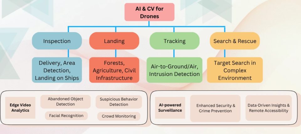
Various implications and benefits of AI in a drone security system
Use Cases of AI in Drone Security Services
Drones have various applications across industrial sectors, including computer vision object detection and identification in complex environments. In this section, we will go through some of them one by one.
Law & Defense
Crowd monitoring is an essential use case of AI-powered drones flexibly deployed by law enforcement parties for investigating accidents, traffic control, rescue operations, analysis of crime scenes, etc. With real-time cognitive awareness, these systems reduce response time and enhance the safety of defense personnel in large combat areas, track suspects, and identify missing suspects or wanted criminals. These also provide sustained oversight and deep insights into situational awareness and assess the presence of any type of danger in a crime scene to avoid further loss during police task force operations.
Developed by drone surveillance companies, these effectively patrol vast stretches of borders in real-time and detect suspicious occurrences and unauthorized lines of control crossings. At times of natural disasters, AI empowers drones to assess risks, identify affected and risk-prone areas that require immediate attention, locate survivors, and facilitate relief efforts, risk mitigation, disaster management, and response strategies.
Agriculture
In agricultural and subterranean surveillance, AI and CV assist UAV drone land surveying in tasks like counting trees and classifying crops across huge fields through analysis of high-resolution aerial plantation imagery. This eliminates manual efforts, inaccuracy, fatigue, and time consumption for data processing in plantation-related software. It eases management of tree assets and inventory database, detection of diseased plants for real-time intervention, and segregation of field areas into demarcated blocks for consistent monitoring and productivity.
AI-enabled defect detection algorithms can be used to detect structural corrosion, cracks, irregularities in crop growth patterns, and overgrowth in vegetation. Image recognition and analysis techniques can help in identifying field soil anomalies like erosion or nutrient deficiencies, pest infestation, and irrigation-related issues like dry patches or overwatering. Drones can analyze moisture levels, spectral data, plant health indicators, color patterns, etc. Through this proactive approach, drones enhance operational resilience, targeted intervention, and efficient use of resources, and reduce chemical usage, leading to sustainable farming, and better and healthier crop yields.
Premise Security
A drone security system for home, warehouses, indoor facilities, or large outdoor areas can be used for counting and recognizing nearby people, cars, and other objects by analyzing aerial video feeds using ML algorithms. It considers parameters such as lighting, altitude of flight, lighting conditions, payload range, and time of day that directly affect the quality of the image. Advanced AI analytics can swiftly differentiate between suspicious activities or breaches and the normal environment and notify concerned authorities with graded, segmented, and geo-tagged alerts cum georeferencing solution regarding the same for improving responses.
The DL models are trained on previously collected, manually annotated, long and varied drone video footage recorded from various angles to replicate eye-level views and avoid blind spots. The models extract facial geometry features to enlarge small faces captured per frame in the automatic attendance system, which is difficult in the case of land-based applications. Such optimization enables scalable installations, quicker computation rates, processing time, and real-time facial recognition.
Infrastructure Development
AI-powered drones capture aerial images of remote infrastructure and building facades for thorough inspections, identifying defects and conducting risk assessments automatically. These ensure timely intervention and maintenance of critical infrastructure and equipment such as water, gas, and sewage pipelines, power lines and plants, public spaces, telecom towers, transportation corridors, and bridges. Through this predictive approach of 3-D mapping, the drones can lower downtime by identifying intrusions, potential chemical spills, cracked glass, corrosion, overheating, cracks, rust, peeled paint, structural anomalies, and damage as per government standards, assessing fire-hazard sites to avoid, and increasing the efficiency of inspections.
Surveillance drones at night also ensure that personal protective equipment is worn consistently in high-risk zones; unauthorized access to construction areas is prohibited, and so is theft of materials, machinery, and tools. All in all, these systems overcome the shortcomings of traditional methods for inspection and data collection, such as hard-to-reach infrastructure, high complexity, time consumption, and labor intensiveness.
Environmental Monitoring
Environmental conservation and monitoring are being improvised by non-invasive AI-powered drones across the globe. These systems assist in mapping wildlife corridors and tracking their movement, identifying illegal poaching and logging activities, detecting rare species or a specific population and reforestation areas, approaching natural disasters and mitigation, supporting sustainable use of resources, and proactively monitoring vulnerable ecosystems and deforestation.
In the case of marine environments, the drones help in recognizing bleaching, assessing and mapping coral reef structures, and planning for conservation. These systems empower prompt incident response, fighting climate change, predicting security threats, detecting anomalies, preserving biodiversity, and restoring habitats in real-time using AI, CV, ML, and fuzzy logic.
Get a Sky-High Upgrade with KritiKal
KritiKal Solutions can assist you in developing and manufacturing advanced autonomous drone-related technology integrated with smart cameras and intelligent video analytics that enhance perimeter security. AI-driven and real-time privacy-securing surveillance allows drones to operate independently and in swarms during preset patrols. Our drone tech enhances the overall performance of security systems to swiftly respond to alerts, risks, disasters, accidents, suspicious activities, etc. CV and ML-powered solutions for drones seamlessly integrate with other robotic systems for coordinated responses during operations.
Our drone security services enable these systems to navigate autonomously and detect objects accurately, thus transforming safety and operational efficiency, especially in the case of critical regions like prisons, airports, and others in smart cities. Our AI-powered drone tech is being widely adopted across various sectors like agriculture, disaster and emergency response, and more for driving innovation while adhering to regulations, privacy, safety, and ethics of UAV deployment. Please get in touch with us at sales@kritikalsolutions.com to learn more about our drone technology products, and solutions and to realize UAV-related requirements.

Mohit Kumar Gupta currently works as a Senior Testing Engineer at KritiKal Solutions. He has expertise in firmware embedded electronics development, GitHub, C, hardware testing, validation, and more. With his ability to work efficiently in teams and extensive experience of working in this industry, he has assisted KritiKal in delivering various projects to some major clients.