

 Global
  United States
What is Object-Based Image Analysis ?
Object Based Image Analysis (OBIA) is a contemporary computer vision technique that helps in analysing and identifying the image of an object as compared to pixel-level classification in case of image classification and localization. It is an approach that is being widely adapted since it involves grouping of objects from their pixels as polygonal homogenous clusters, on the basis of their similarities at the spectral or geological unit-level and generates high-quality, robust and less noisy results.
It is basically an amalgamation of two well-known computer vision sub-techniques, namely, image segmentation and classification. Here, the former refers to a process of locating, demarcating by boundaries and forming image objects, where a digital image is divided into various image segments for easy analysis.
Each pixel sharing similar characteristics with others is assigned a label, and numerous such segments form the image collectively as a matter of fact. Whereas, in case of image classification, similar to aforementioned technique, pixel-level categorization is done, but instead of boundaries, specific classes or labels are assigned to groups of each vector forming the image. In this way, a communication bridge is set up between the image analysing machine and the camera in order to understand its content. Difference lies in the fact, that segmentation can be done on multiple objects usually highlighted in different colors, separating objects from their backgrounds, but classification is done only on one object in the image, assigning it a label.
The overall image analysis software market is projected to reach a market value of USD 7.67 billion by 2028 from USD 3.97 billion in 2021, that is, a CAGR of 9.9% is expected. This blog deals with the various techniques of OBIA. It also tells about how this sort of analysis is applied in images and videos of real-life situations.
Techniques of OBIA
Object-based image analysis can be used for extracting images through remote sensing using high-resolution satellites. Other sources of integrating data into OBIA systems can be LiDAR, ancillary data or multispectral imagery, all of which can be combined via methods like data stacking or feature-level fusion, to obtain better results. The techniques used in OBIA are given below:
Segmentation
This is the first step of OBIA in which helps in forming homogenous regions within the image on the basis of similarities in texture, shape, color, intensity etc. When such similar pixels are clustered together, features of objects or areas in focus can be gathered and given meaning to. This can be done with the help of algorithms that may be one of the following:
Region Growing: In this case, predefined criteria like color, shape etc. are used to group pixels with homogenous properties together, starting from seed pixel.
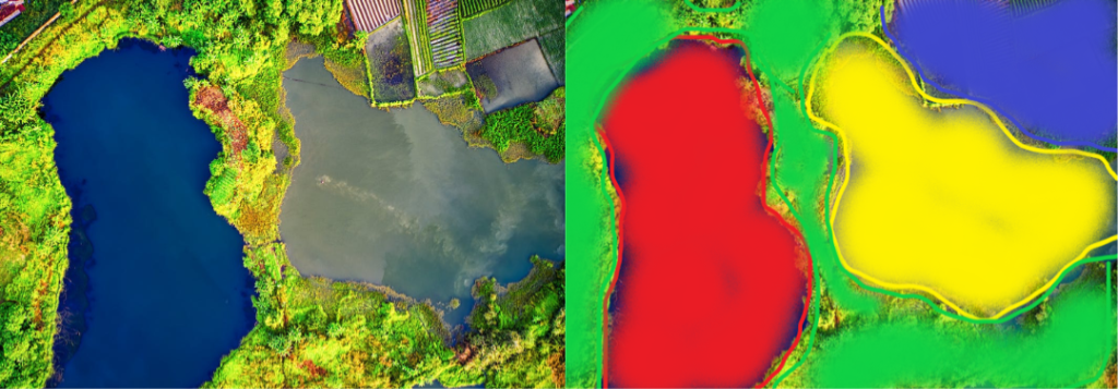
The above image represents aerial imagery of crop fields and water source before (left) and after segmentation.
Watershed Transform: This technique is based on the analogy of grouping catchment basins and segments with boundaries as per watersheds’ occurence. Simply put, the image is treated as a topographic surface, where the algorithm floods to segment regions along watershed lines.
Mean-Shift Segmentation: Pixel values are shifted towards the mean calculated in a particular spatial neighbourhood repeatedly so as to create homogenous segments.
Feature Extraction
After segmentation, feature extraction is conducted from each and every segmented part. The system considers spectral features such as color, size etc. obtained as statistical values from the satellites or drones or contextual information. This technique helps in quantifying each segment on the basis of certain attributes making it easier to classify in the following ways:
Texture Analysis: This analysis is used by algorithms like Gabor filters and Gray-Level Occurrence Matrices for quantifying segments.
Shape Descriptors: Features can be extracted from segments based on the measures of geometric properties like eccentricity, perimeter, area and compactness.
Statistical Information: Pixel-wise properties in each segment defined as mean, standard deviation etc. for better classification with adequate accuracy.
Classification
This technique involves labelling or assigning specific classes to these obtained image segments on the criteria set according to features extracted. One can determine the type of land cover, vegetation, represented objects etc. By labelling these segments with the help of algorithms that may be rule-based or machine-based in nature.
Rule-based Classification: Predefined rules, logical conditions or criteria based on domain knowledge are applied for classifying segments under specific labels.
Unsupervised Machine Learning: This includes performing object-based image classification by using algorithms like k-means that are capable of grouping segments into respective classes without any predefined criteria or use of decision criteria data.
Supervised Machine Learning-based Classification: These are some of the commonly applied automated classification techniques that classify image segments on the basis of adaptation to complex patterns within labelled data training. Some examples are as follows:
- Support Vector Machines: An optimal hyperplane is searched for or devised in a high-dimensional feature space and classes are differentiated.
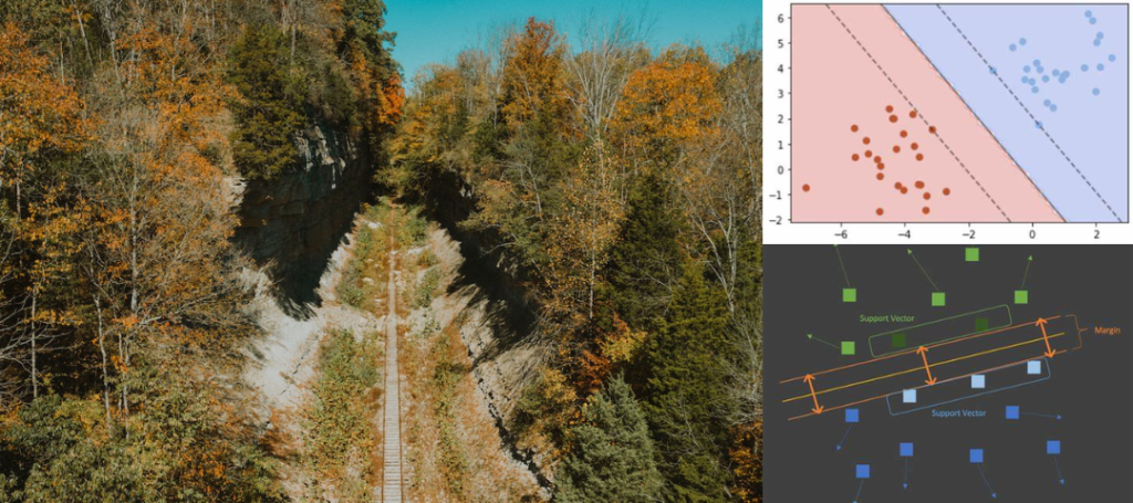
The above image represents SVN classification applied to aerial imagery of forest nearby railway tracks.
- Neural Networks: End-to-end deep learning-based image classification can take place in this case like Convolutional Neural Networks.
- Random Forests: Multiple decision trees are developed using ensemble learning methods and their results are combined for better accuracy.
Post-Classification Processing
This step involves computer vision solutions such as smoothing, Gaussian or majority filtering of boundaries between segments, erosion and dilation like morphological operations for removing small isolated segments as well as filling gaps between segments, enhancing images etc. Such processing comes into play after initial classification is completed, for visual coherence and segmentation accuracy. Spectral indices like Normalized Difference Vegetation Index can be used to enhance classification outputs.

The above image represents aerial imagery of crop fields before (left) and after classification.
Object-based Change Detection
It is also possible to detect changes in object segmentations such as land cover or vegetation features by comparing their images captured during different time periods post-classification and then quantifying them accordingly. Image differencing is conducted by calculating pixel-level differences in the images of changed areas. Furthermore, Change Vector Analysis is done to quantify the spectral vectors with direction and magnitude of changes in pixels in the corresponding images.
Spatial Relations and Contextual Analysis
As mentioned in case of feature extraction, contextual information can be used to accurately classify images captured, where spatial poximity relations like distance, connectivity and adjacency, amongst neighbouring segments play an important role. Boundaries can be refined by using Edge-detection algorithms like Canny-Edge Detector which identifies edges in segments and Gradient-based Edge Detector that identifies pixel-level changes to define segment edges.
Applications of OBIA
Given below is a brief account of applications of object-based image analysis:
Urban Planning
Object-based image analysis can be used to identify and provide class labels for various urban areas and their features such as parks, buildings, common halls, roads etc. Such type of valuable information is required for urban planning and city development projects. It can also be used for infrastructure planning, for example, identification and monitoring of utilities, transportation networks like roads and railways for further development.
Precision Agriculture
OBIA is used for crop monitoring, checking on their health, identifying chances of pest-infestation, and allocating resources in variable crop field areas. It can be used for vegetation monitoring as well for tracking its expansion or contraction of its total cover.
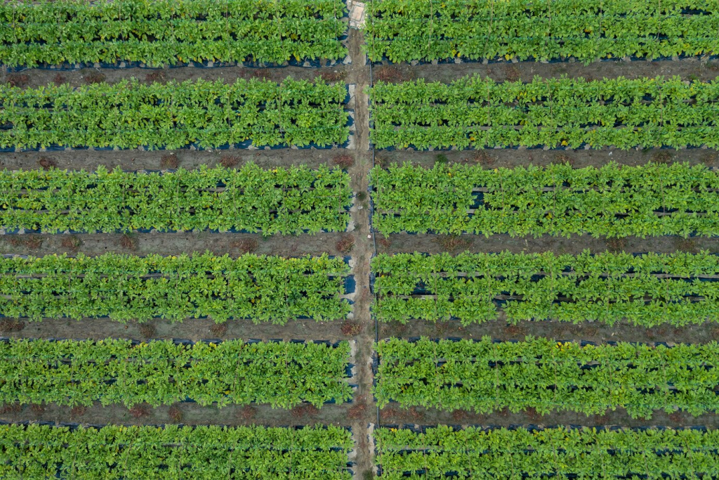
The above image represents aerial imagery of crop field to determine pest infestation during classification.
Land Cover Classification
This is quite an important application of OBIA, as it classifies land under observation for plant-based agricultural purposes as natural and semi-natural aquatic vegetation (regularly flooded vegetation), cultivated aquatic areas (regularly flooded areas, water bodies), artificial surfaces (associated urban areas), cultivated and managed terrestrial areas, natural and semi-natural terrestrial vegetation (prairies, agro-forestry regions and crop fields (crop fields, farms), managed grasslands, areas with vegetational features such as field margins, hedgerows, woodlots, buffer strips, forests etc), and bare lands (deserts, excessively burnt infertile lands, dried-up valleys etc.)
Disaster Management
Object-based image analysis can assess and identify natural disaster affected areas like, wildfires, floods or earthquake-hit zones. Required responsive assistance can be provided to people impacted and plausible economic assessment of these areas can be done for recovery planning using this technique.
Environmental Monitoring
With the help of OBIA, changes in landscapes such as deforestation, land occupational terrorities, urban sprawl etc. can be monitored. It is used for forest inventory and log activities monitoring (regions with valuable products like oak, pine, medicines etc), tree species labelling and more for sustainable forest conservation. Such image analysis is also applied in wildlife monitoring in order to track animal movements as well as to analyse human activity impact on their ecosystems.
KritiKal’s Expertise in OBIA
KritiKal Solutions has worked on developing computer vision solutions like object-based image analysis for a lot many mid-sized and large organizations. Some of the use cases developed were, geo-mosaicing, aerial geolocation and geo-registration system, tea estate video analytics and geofencing, automated formation of geo-spatial documents from images etc to name a few. With over two decades of expertise in this field and an expert team of developers, we assure our clients to deliver OBIA solutions of utmost quality. We also provide custom software development services specifically for OBIA system integration and deployment as well as for business-specific needs. Please call us or mail us at sales@kritikalsolutions.com to avail our services.
Conclusion
Object-based image analysis is used for remote sensing and digital satellite and aerial image segmentation using spatial and spectral information. It is applicable in various fields such as disaster mitigation, agriculture, urban planning and development, land cover mapping, environmental monitoring etc. It involves few techniques such as feature extraction, segmentation, classification, post-classification processing and object-based change detections, alongside specific algorithms or their combinations that provide highly accurate results with respect to assigning classes to segments and identifying object-based changes. With advancements in technology, more new techniques and subsequent algorithms with higher accuracy and reduced lead time, are likely to emerge in the future, thereby, improving OBIA.

Narveer is an experienced Python Developer with a demonstrated history of working in the Information Technology and Services Industry. He is skilled in Python Programming Language, Deep Learning, Machine Learning, TensorFlow, and OpenCV technologies. His dedicated efforts significantly contributed to KritiKal Solutions’ successful completion of diverse computer vision projects for SMBs and Fortune 500 companies.
Backlinks Free Tool
December 5, 2025I discovered your weblog site on google and test a couple of of your early posts. Proceed to keep up the excellent operate. I simply additional up your RSS feed to my MSN News Reader. In search of forward to reading extra from you in a while!…