

 Global
  United States
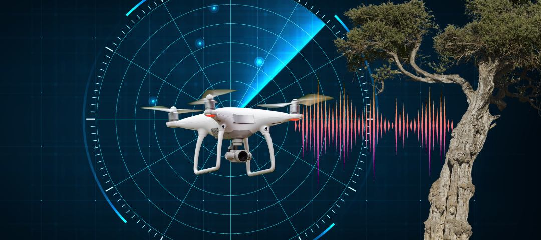
Autonomous drones are powered by various integrated state-of-the-art techniques and technologies that enable them to accurately perceive their environment and make real-time informed decisions to avoid obstacles. Drone obstacle avoidance is of paramount importance for enhancing flight safety. It can be used by using technologies like terrain after using GPS, IMU, satellite positioning, different types of sensors, computer vision-enabled algorithms that localize objects through cameras and render various use cases, all of which are explained with examples in this blog. Robust collision avoidance technology is constantly under evolution and refinement by manufacturers, gradually building trust and prevalence amongst drone enthusiasts and professional operators.
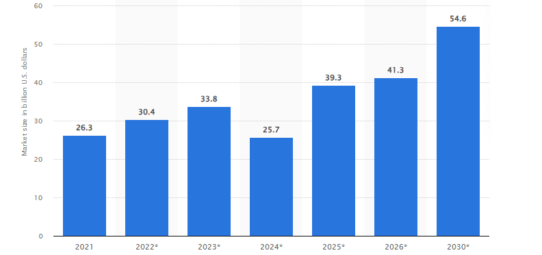
Global revenue of drones with collision avoidance from 2021 to 2030
How Does Drone Obstacle Avoidance Work?
Drones typically detect and safely navigate around obstacles to avoid them in complex environments by using a combination of sensors and vision-based algorithms such as the following:
- Ultrasonic Sensors: We know that Infrasonics can range from 0.001 Hz to 20 Hz, Acoustics may lie between 20 Hz and 20 kHz and Ultrasonics range from 20 kHz to above. The ultrasonic sensors emit sound waves in this given range, then they measure the time taken by the waves to get reflected by the obstacle on path. This data is interpreted by algorithms to detect the distance (5-20 m) between the drone and the obstacle present within the sensor’s range, and this is how drones avoid obstacles.
- Infrared Sensors: Algorithms can process data obtained from infrared sensors which have similar working as ultrasonic sensors. We also know regarding the various light ranges in the electromagnetic spectrum which includes Cosmic rays (10–12 m), Gamma rays (10-10 m), X-rays (10-9 m), Ultraviolet rays (10-8 m), Infrared rays (10-6 m), Microwaves (10–4 m), Radar waves (10-3 m), Radio waves (100 m) and Broadcast band (102 m). These sensors emit infrared waves and measure the time taken for it to get reflected by the obstacle present at close range (3-4 m) and reach the sensor.
- LiDAR: Certain algorithms process information obtained from Light Detection and Ranging sensors to measure distances of drones from obstacles, and then generate high-resolution 3D topographical maps of the environment. For example, Vector Field Histogram (VFH) algorithm which processes LiDAR data and slows down the drone’s speed, this helps it to precisely locate obstacles and avoid them.
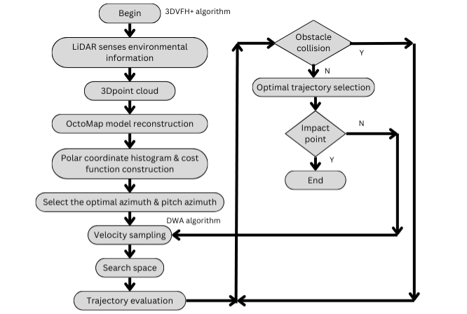
The design flow chart of VFH fusion algorithm in drones with collision avoidance
- Computer Vision: Drones are equipped with First-Person View high-resolution cameras. Integrated algorithms like You Only Look Once (YOLO) and Single Shot MultiBox Detector (SSD) can analyze images obtained from the same and detect obstacles in time efficiently for intelligent video analytics. Computer vision techniques such as object detection and depth estimation are used to detect, identify and locate obstacles as well as estimate their distance from drone.
- SLAM: Onboard Simultaneous Localization and Mapping algorithm enable drone obstacle detection and create environmental maps and self-localization in the same. They continuously update this map throughout their movement and change in determined position to navigate without colliding autonomously.
- Path Planning: After receiving inputs from algorithms processing sensor and camera-based data points or obstacles, path planning algorithms like Dijkstra’s, utilize metaheuristics and generate a collision-free path for the drone by considering its current position, obstacle locations, speed etc.
- Reactive Control: As the name suggests, reactive control algorithms assist drones to react in real-time to unexpected obstacles and environmental changes by adjusting the drone’s trajectory and avoiding obstacles.
- Machine Learning: Techniques such as different types of neural networks can improve drone’s obstacle detection and avoidance, as they are trained on large and varied datasets of obstacles images, which has in turn improvised the accuracy of these models empowering drone obstacle avoidance.
Importance of Drone Obstacle Detection
Obstacle avoidance presents a plethora of applications for drones throughout various sectors:
Prevent Accidents
Equipping drones with collision avoidance capabilities can reduce occurrences of crashes that may be costly, rightly assures one’s investment and safeguards the well-being of animals, people and properties. Also, the enthusiasm for drones is increasing day by day amongst professionals and hobbyists as is evident from the surging CAGR of 0.36% by 2028, where the current drone global market revenue in 2024 is approximately US $1.4 billion. Therefore, with increasing popularity, skies are getting more and more crowded, thus making it crucial to integrate efficient and reliable obstacle avoidance systems in drones.

Drones avoid obstacles during e-commerce delivery
Enhanced Delivery
Scenarios where drones avoid obstacles are becoming frequent and serve as the most promising areas for delivery services industry. Taking advantage of this paramount feature, medical dispensaries and e-commerce giants such as Google and Amazon are investing in drones with collision avoidance as it plays a pivotal role in efficient drone delivery systems. Now drones can easily navigate around vehicles, pedestrians, buildings etc. obstacles and realize safe delivery.
Aerial Surveillance
Drone obstacle detection is benefiting surveillance industry with high-resolution cameras, enhancing capabilities of security firms and law enforcement for automated visual inspection. They conduct aerial patrols autonomously, identify threats and transfer object or person detection analytics with real-time video footage to their operators present in the secured area over ground.
Disaster Mitigation
Drone obstacle avoidance has revolutionized disaster response through enhanced search and rescue operations. These specially equipped objects can travel over challenging terrains such as deep mines, steep mountains, narrow defiles, dense forests, hazardous or militant areas etc. where it may be difficult for people or vehicles to reach and notify their operators regarding the region, missing persons, survivors, and other activities.
Others
Autonomous drone solutions with this technology is assisting the agricultural sector in pest control, crop monitoring, precision farming, irrigation management etc. In the film making industry, it is used for obtaining creative shots from dynamic filing angles and smooth camera movements. Other than these, it is already used for construction site analysis, topographical surveys, terrain 3D mapping etc.
Navigate the Skies Confidently with Us
With advancements in cameras, sensors (IR, Ultrasonic, Depth), and other environmental data gathering technologies, drones avoid obstacles efficiently in real-time and are transforming regulatory possibilities and various industries such as aerial surveillance, security, film making, e-commerce delivery services, disaster response etc. While unlocking new use cases across them. The future is likely to be shaped by autonomous drones powered by precise collision avoidance technology and their versatile applications that overcome the restrictions imposed on the capabilities of traditional drones via pre-programmed flight paths or remote-controlled operations.
KritiKal Solutions can act as your one-stop solution for eliminating all drone obstacle detection related challenges such as limited visibility due to low lighting, inclement weather conditions, high frequency of obstacles rendering overlapping topographical maps, low sensor accuracy, and data processing complexity etc. which obstruct the proper functioning of computer vision algorithms relying on visual data. We incorporate effective sensors and enhanced algorithms to neutralize the effects of such conditions retain thoroughly pre-processing imageries and videos for better analytics. We continue to contribute to this evolving landscape of surveillance through aerial mosaicing and geo-registration system, construction survey and analysis, video analytics of tea plantations, horizon detection, traffic surveillance, illegal sand mining detection and much more. Please mail us at sales@kritikalsolutions.com to avail our services.

Sahil Amin currently works as a Project Manager at KritiKal Solutions. With over 22 years of experience and utmost dedication, he has helped KritiKal in delivering various projects by ensuring that every milestone is met through effective communication, collaboration and innovation.