

 Global
  United States
What are UAVs?
Exponential growth has been observed in drones over the years, especially for highly detailed UAV drone land surveying, accurate mapping and precise positioning in the geospatial industry as an alternative to manned surveillance. The full form of UAV is Unmanned Aerial Vehicle, and as the name suggests, such an aircraft is unpiloted and is operated without a human pilot, crew or passengers onboard. They are available in varied sizes, designs, shapes and price ranges, right from smaller hand-launched or remote-controlled models to software-controlled military drones for surveillance. The global revenue for drones amounts to US $1.4 billion as of 2024 and is expected to grow at a CAGR of 0.36%, reaching a volume of 28 million units by 2028.
Unmanned Aerial Vehicles were first launched in 1849 by Austrians to invade Venice using unmanned balloons. In 1915, the British military captured 1,500 sky view maps using aerial photography by unmanned vehicles. Successive advancements in this technology led to the making of the first pilotless aircraft during the First World War. In 1930, the US Navy started testing radio-controlled aircraft, which later led to the development of Curtiss N2C-2 by 1937. In the 1980s, RQ2 Pioneer was introduced as a reconnaissance aircraft of medium size and in 2014, UAVs were adopted to deliver Amazon packages to customers and shoot promotional real-estate videos. We shall further expand our understanding of drones and the benefits of their exploration of the realm of spatial analysis in this blog.
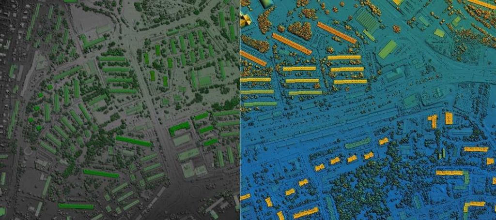
Aerial imagery obtained during UAV land surveying of crop fields before (left) & after classification
Components of Unmanned Aerial Vehicles
An unmanned aerial vehicle has many components such as the following:
- Airframe: It is basically the structure and skin of the drone that holds all the components in their respective positions and determines the overall size (commonly 1 – 10 lbs) and shape as well. The drone’s design affects its flight stability and functional efficiency. They can be classified as nano drones (0.55 lbs), microdrones (0.55 – 4.4 lbs), small drones (4.4 – 55 lbs), medium drones (55 – 330 lbs) and large drones (>330 lbs).
- Propulsion System: Drones may have internal combustion engines, multiple brushless electric or gimbal motors that power the propellers, which in turn generate lift, thrust, direct-drive angular positioning and enable flying. Certain plastic, wood or carbon fiber-made tractor-type propellers are placed in the front, while contra-rotating pusher propellers are placed in the back, for example, DJI Phantom. UAV solutions or drone platform types can be rotors or fixed wing where the former can be single-rotor or multi-rotor like tricopters, quadcopters, hexacopters and octocopters. While fixed wings may include landing drones or hybrid vertical takeoffs that do not require runways.
- Flight Controller: It processes data received from battery monitors, IMU, onboard light digital sensors such as gyroscopes, Time-of-flight (ToF) LiDAR, photogrammetry sensors, thermocouples, GPD module (GPS receiver, satellite navigation systems like Glonass, FPV and magnetometer), accelerometers, 3D sensors, multi or hyper-spectral sensors like airborne and terrestrial laser scanners (ALS, TLS), collision avoiding sensors like ultrasonic (Sonar), IR, Monocular Vision, computer vision object detection etc. for navigation, latitude, longitude, altitude, motor speed and stability control. Sensors may consist of electro-optic imagers, infrared markers, laser rangefinders and mid-wave infrared imagers for providing control range operations like waypoints, follow me, failsafe, autopilot etc. Shorter booms which are arms or struts that extend outward from the drone, provide maneuverability and reduce propeller downdraft interference.
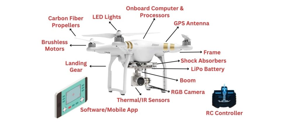
Various components of an Unmanned Aerial Vehicle
- Electronic Speed Controllers: The ESCs managed by flight controllers are responsible for sinusoidal regulation of the power of flight sent to motors from rechargeable LiPo batteries for smooth, precise movement and dynamic braking. The choice of DC batteries converted to 3-phase AC energy supply by ESCs affects the overall flight performance and time. Certain tethered drones are physically tethered to a base station and provide direct power supply to other autonomous drone solutions that may be facing challenges with power supply.
- Onboard Computer & Receiver: Onboard computers, avionics mission systems or flight critical processors are usually present in advanced autonomous drone solutions like Autel’s Dragonfish series, for avoiding obstacles, performing complex tasks and autonomous flights. The (r/c) radio receiver unit is responsible for communicating via radio waves, Wi-Fi (minimum number of channels required to control a drone is 4-5) with the ground station, remote control or software during its independent flight plan as per its embedded system for performing timed operations. The make of the antenna also depends on the receiver, it may be cloverleaf, helical and helps to avoid multi-path effect or blind angle.
- Payload: It includes cameras, sensors, weaponry, disaster aid, communication equipment etc. that are triggered by flight controllers and are required for fulfilling the drone’s commercial, personal, hobbyist or enterprise-related purpose such as high-definition aerial photography, mapping, live-streaming (Zoom, GoPro, Inspire 2) and surveillance. Autonomous drone solutions may or may not include a fixed or retractable landing gear depending on the payload, for example, Trimble UX5, SenseFly eBee.
Benefits of UAV Land Surveying
UAV solutions have been in talks because of their versatile and affordable utilities. They assist their controllers in performing tasks that may be too dangerous or tedious for them to perform. Given below are some of the use cases cum benefits of utilizing autonomous drone solutions in various sectors.
Urban Planning & Development
UAV drones for land surveying are commonly used in site planning, progress monitoring, topographic mapping in the field of construction and infrastructure development. These provide accurate volumetric measurements, detailed aerial surveys as well as 3D construction site models for better planning, designing and management of the project. Planners and developers can assess zoning regulations and land usage as per infrastructure requirements during urban planning or smart city development. They make informed decisions by going through elevation data, aerial imagery and 3D models of the urban area under consideration obtained via drones. UAV solutions are also used for vision inspection systems, structure assessments, condition surveys, defect or hazard detection across transportation infrastructure such as bridges, railway tracks, metro lines, roads etc. without disrupting traffic flow.
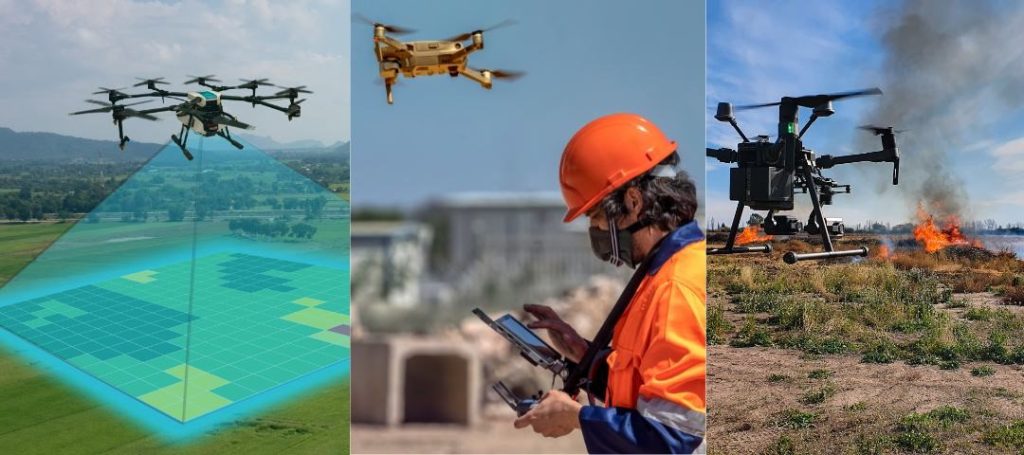
The above image shows various use cases of UAV drone land surveying
Agriculture & Precision Farming
UAV land surveying is also utilized for crop monitoring, yield estimation, pest detection and control, and precision farming in the agriculture field. They are equipped with thermal imaging and multispectral cameras for intelligent video analytics. Collected data can be processed and analyzed with the help of Geographic Information System (GIS) that creates 3D maps, models, orthomosaics etc. by agriculturalists. Ground-disturbing activities during traditional survey methods such as heavy machinery, impact on field and environment can be avoided with non-invasive UAV land surveying. Farmers gain real-time insights on pest infestations, crop health, soil moisture levels, which in turn helps them to increase productivity while optimizing resource management.
Environmental Monitoring & Conservation
Drones support environmental conservationists in surveying habitats, tracking wildlife or rare species population and monitoring changing ecosystems for taking further restoration steps, for example, localization and revival of extinct plant species by National Tropical Botanical Garden. UAV solutions are useful for facilitating deforestation assessment, habitat fragmentation, biodiversity conservation planning and initiatives. Similarly, they are utilized for wildfire monitoring, tree health assessment, forest inventory tracking, forest disturbances, illegal logging or poaching, invasive species infestation tracking, and other sustainable forestry management practices.
Disaster Response & Emergency Management
Unmanned aerial vehicles are an eminent part of natural disaster and emergency response. These are deployed to alert regarding impending natural disaster and post-disaster assessment such as for rapid area and property damage assessment, disaster mapping, search and rescue missions Emergency responders can benefit with real-time situational awareness which helps them to effectively prioritize response efforts and resource allocation. These also play a crucial role in conducting geological surveys, slope stability assessment and stockpile volume measurements in quarrying and mining operations, thus, optimizing extraction process, monitoring site conditions and ensuring compliance of environmental regulations.
Moving Forward
With the rise in drone adoption, safety, speed, accuracy are inevitably the key considerations for future advancements in the UAV drone land surveying and mapping fields, especially since the successful deployment of unmanned traffic management in 2019 across Europe, an initiative that is currently under integration for safer airspace and roadways access in the US. Greater interoperability of vision technology-based processing and insight generating software with UAVs’ efficient data collection is surely to play a key role in supporting dynamic geospatial data and object-based image analysis.
KritiKal Solutions has complemented the rise of drone technology in the geospatial industry by playing a pivotal role as a trailblazer assisting various companies with similar requirements over decades. Our expertise not only extends developing state-of-the-art UAV drones for land surveying but also transforming spatial insights generated per effective flight. We continue to contribute to this evolving landscape of surveillance through aerial mosaicing and geo-registration system, construction survey and analysis, video analytics of tea plantations, horizon detection, traffic surveillance, illegal sand mining detection and much more. We can take care of your intricate requirements, customizations through special development kits like ESC reprogramming, as well as provide testing services and solutions around issues like low-quality gimbal camera or motor, rolling shutter, vibration, jello or barrel effects, boom examination, flying faults, and areas under research like payload waterproofing, low-noise propellers, vision-based stress crack detection in motor mount etc. Please mail us at sales@kritikalsolutions.com to avail our services.

Chandan Thakur is a passionate and driven Production Manager with expertise in handling and controlling multiple projects involving various technologies and industries. His perspective on mobile engineering, telecommunications, lean manufacturing and approach to efficient production process has helped in effective communication, coordination, and collaboration with the clients, vendors, and internal teams.